CW31037
Garmin
Garmin BlueChart® g3 Vision® HD - VAW450S - The Gulf - microSD™/SD™
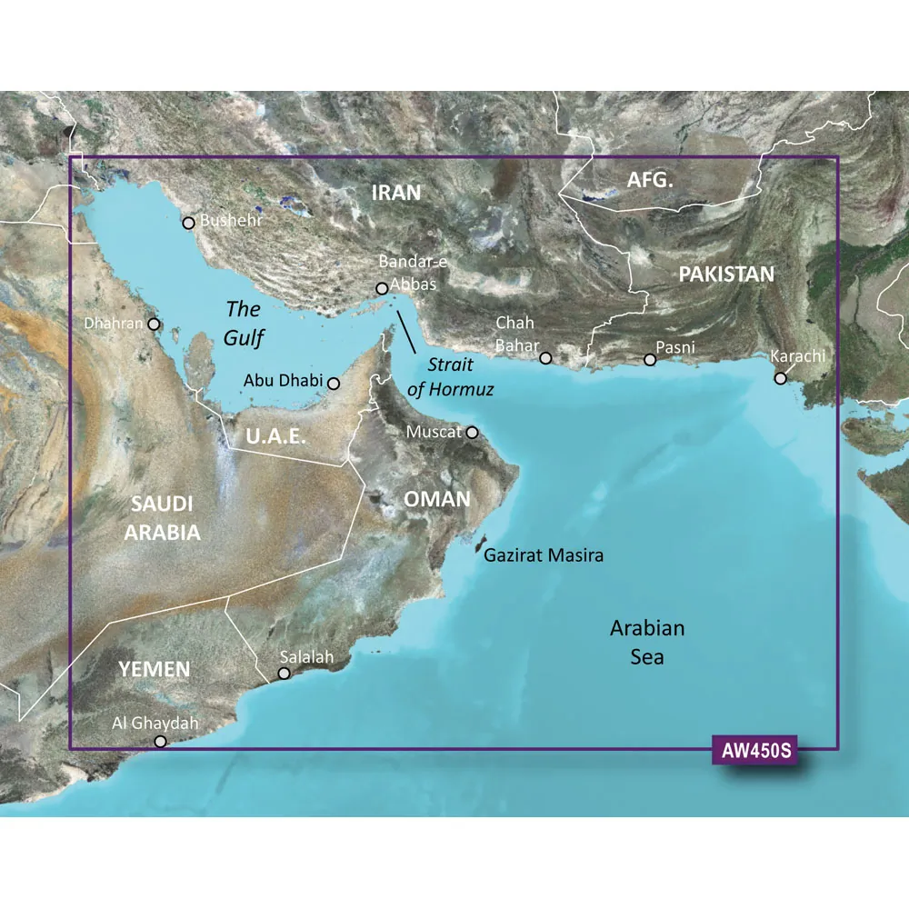
<p><strong>BlueChart® g3 Vision® HD - VAW450S - The Gulf - microSD™/SD™</strong></p><p><strong>Coverage:</strong></p><p>Detailed coverage of Kuwait, Saudi Arabia, Qatar, United Arab Emirates, along the southern coast of the Gulf, including Al-Fuhaihil, Ad-Dammam, Bahrain, Ad-Dauha, and Abu Dhabi. Coverage of Iran along the northern coast of the Gulf including Bushehr and Bandar-e Abbas. Coverage of the Strait of Hormuz and the Gulf of Oman. General coverage of the Arabian Sea from Qamar Bay to the Delta of the Indus River. </p><p><strong>Our Premium Chart Offering</strong></p><ul><li>Derived from official charts and private sources to provide navigational aids, spot soundings, depth contours, tides and currents, and detailed harbors and marinas</li><li>Garmin Auto Guidance technology shows a suggested route to a destination¹</li><li>Depth Range Shading for up to 10 depth ranges enables you to view your target depth at a glance</li><li>Up to 1-foot contours provide a more accurate depiction of the bottom structure for improved fishing charts and navigation</li><li>Shallow Water Shading feature allows for depth shading at a user-defined level to aid in navigation</li><li>Unique 3D views like MarinerEye and FishEye provide additional perspective both above and below the water line</li><li>High-resolution satellite imagery of ports, marinas, bridges and navigational landmarks for superior situational awareness</li></ul><p><strong>Auto Guidance¹</strong></p><p>Auto Guidance technology quickly calculates a suggested route using your boat's dimensions and a suggested path to follow.</p><p><strong>Depth Range Shading</strong></p><p>Displays high-resolution Depth Range Shading for up to 10 depth ranges so you can view your designated target depth.</p><p><strong>Detailed Contours</strong></p><p>BlueChart g3 Vision HD features 1-foot contours that provide a more accurate depiction of bottom structure for improved fishing charts and enhanced detail in swamps, canals and port plans.</p><p><strong>MarinerEye View</strong></p><p>Provides a 3-D representation of the ocean floor as seen from below the waterline.</p><p><strong>FishEye View</strong></p><p>Provides a 3-D representation of the surrounding area both above and below the waterline.</p><p><strong>High-resolution Satellite Imagery</strong></p><p>High-resolution satellite imagery with navigational charts overlaid gives you a realistic view of your surroundings so you can navigate with a clear moving-chart representation of your boat’s position. It’s our most realistic charting display in a chartplotter.</p><p><strong>Aerial Photography</strong></p><p>Crystal clear aerial photography shows exceptional detail of many ports, harbors and marinas and is ideal when entering unfamiliar ports.</p><p><img src="https://productimageserver.com/prop65/6pt.png" alt="Warning" /><strong>WARNING:</strong> This product can expose you to chemicals which are known to the State of California to cause cancer, birth defects or other reproductive harm. For more information go to <a href="http://P65Warnings.ca.gov">P65Warnings.ca.gov</a>.</p><strong>This product may not be returned to the original point of purchase. Please contact the manufacturer directly with any issues or concerns.</strong> <!--- cis2:m2hqmpZo --->
Specifications
| details | Detailed coverage of the Gulf region and surrounding areas.Includes Garmin Auto Guidance technology for route planning.Up to 10 depth range shading for enhanced navigation.1-foot contours for accurate bottom structure representation.Shallow Water Shading to aid navigation in shallow areas.3D views for below and above water perspectives.High-resolution satellite imagery improves situational awareness. |
Available From 1 Seller
| Seller | Condition | Qty | Price | Location | Updated | Action | |
|---|---|---|---|---|---|---|---|
|
Aztek Computers
VAR |
Refurbished | 1 | $154.04 | Frisco, TX | Mar 18 |